Geography and climateMain articles: Geography of Ireland and Geography of the United Kingdom
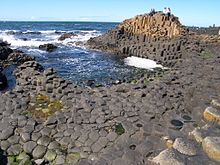
The Giant's Causeway, County Antrim Northern Ireland was covered by an ice sheet for most of the last ice age and on numerous previous occasions, the legacy of which can be seen in the extensive coverage of drumlins in Counties Fermanagh, Armagh, Antrim and particularly Down. The centrepiece of Northern Ireland's geography is Lough Neagh, at 151 square miles (391 km2) the largest freshwater lake both on the island of Ireland and in the British Isles. A second extensive lake system is centred on Lower and Upper Lough Erne in Fermanagh. The largest island of Northern Ireland is Rathlin, off the north Antrim coast. Strangford Lough is the largest inlet in the British Isles, covering 150 km2 (58 sq mi). There are substantial uplands in the Sperrin Mountains (an extension of the Caledonian mountain belt) with extensive gold deposits, granite Mourne Mountains and basalt Antrim Plateau, as well as smaller ranges in South Armagh and along the Fermanagh–Tyrone border. None of the hills are especially high, with Slieve Donard in the dramatic Mournes reaching 850 metres (2,789 ft), Northern Ireland's highest point. Belfast's most prominent peak is Cavehill. The volcanic activity which created the Antrim Plateau also formed the eerily geometric pillars of the Giant's Causeway on the north Antrim coast. Also in north Antrim are the Carrick-a-Rede Rope Bridge, Mussenden Temple and the Glens of Antrim.
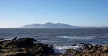
The Mourne Mountains, County Down The Lower and Upper River Bann, River Foyle and River Blackwater form extensive fertile lowlands, with excellent arable land also found in North and East Down, although much of the hill country is marginal and suitable largely for animal husbandry. The valley of the River Lagan is dominated by Belfast, whose metropolitan area includes over a third of the population of Northern Ireland, with heavy urbanisation and industrialisation along the Lagan Valley and both shores of Belfast Lough. The whole of Northern Ireland has a temperate maritime climate, rather wetter in the west than the east, although cloud cover is persistent across the region. The weather is unpredictable at all times of the year, and although the seasons are distinct, they are considerably less pronounced than in interior Europe or the eastern seaboard of North America. Average daytime maximums in Belfast are 6.5 °C (43.7 °F) in January and 17.5 °C (63.5 °F) in July. The damp climate and extensive deforestation in the 16th and 17th centuries resulted in much of the region being covered in rich green grassland.[ citation needed ] The highest maximum temperature recorded was 30.8 °C (87.4 °F) at Knockarevan, near Garrison, County Fermanagh on 30 June 1976 and at Belfast on 12 July 1983.[ citation needed ] The lowest minimum temperature recorded was −18.7 °C (−1.7 °F) at Castlederg, County Tyrone on 23 December 2010.[50]
|